Trending


New NYU data tool shows affordable housing throughout NYC
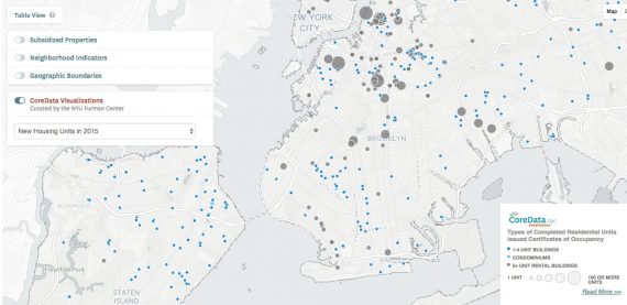
It combines more than 100 different sources of data
The public can now easily track down affordable housing in the city with a new data tool.
New York University’s Furman Center just released CoreData.nyc, an interactive map that shows subsidized housing throughout the city, Brownstoner reported. The tool was created as an update to the Furman Center’s Subsidized Housing Information Project and as a way to make affordable housing information more widely available.
The tool pulls data from more than 100 state, city and federal sources. The housing can be filtered by several different factors, including demographics, land use, flood zones and crime.
“This will provide increased transparency in the complex landscape of affordable housing in New York City, and be a crucial resource for the staff and task forces that we rely on to make recommendations for agreements and restrictions affecting future supply,” City Council Speaker Melissa Mark-Viverito said in a statement.[Brownstoner] — Kat