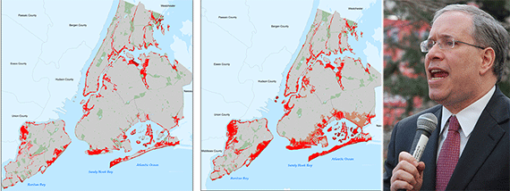
UPDATED, 9:45 p.m., October 30: The New York City flood zones contain 84,000 properties valued at a total of $129 billion, according to a report by Comptroller Scott Stringer’s office.
The report, released on the two-year anniversary of Hurricane Sandy, showed that the Federal Emergency Management Agency identified 60,000 additional buildings that are in areas prone to severe flooding since the last batch of maps in 2010. FEMA maps detail only areas at risk from a 100-year storm, i.e. a storm that has a 1 percent probability of occurring in any given year.
The value of the city’s buildings in the flood zones is up by 120 percent in a four-year period, according to the report cited by Vice News. In Brooklyn alone, value of the buildings in those zones climbed to $36 billion this year from $12 billion in 2010 – a 200 percent jump. The Bronx’s value increase was 36 percent, the website said.
“It’s easy to think that Sandy was a once-in-a-lifetime event, but climate science tells us that rises in sea level and more frequent severe weather will put lives, property, and communities at increased risk,” Stringer told the website. [Vice News] — Mark Maurer
Correction: A previous version of this story incorrectly what FEMA maps identify. They detail areas at risk from a 100-year storm.