
It is one of the paradoxes of the human condition that we take infrastructure far more seriously in the breach than in the observance. We have been known to riot if we have too much water or not enough, if our roads have potholes or if our transportation system is in any way deficient. But just try writing a book — or even an article — on any of the miracles of modern infrastructure and, aside from a few devoted wonks who will take notice, you are apt to be met with stony, truculent indifference from the general public.
All of which makes Gerard Koeppel’s recent book “City on a Grid: How New York Became New York” even more of an accomplishment. Writing in a breezy and congenial style, Koeppel walks readers through the evolution of the city’s built environment, a topic that is, or should be, of interest to anyone involved in New York City real estate. Infrastructure is a subject this native New Yorker knows well. This is Koeppel’s third book on the subject, after “Water for Gotham: A History,” which detailed the evolution of our reservoirs and the provisioning of our water, and “Bond of Union: Building the Erie Canal and the American Empire.”
His latest effort should come as a revelation to most New Yorkers who take their physical surroundings for granted. Thanks to a fine exhibition in 2011 curated by NYU urban studies and architecture professor Hilary Ballon at the Museum of the City of New York, called “The Greatest Grid,” many people may already know that in 1811 the surveyor John Randel Jr. devised the grid that we now inhabit from 14th to 155th streets. But there is a widely held, although mistaken, notion that all he did was get out a ruler and some paper, draw ten long avenues and 141 cross streets and then pack up and go home. In fact, he had to survey every inch of that territory, in 93 maps, which survive to this day and provide a fascinating record of the natural and man-made state of the island of Manhattan before the grid emerged.
Koeppel reveals the violent confrontations and considerable debate at every step of the grid’s implementation, which played itself out not over a few months but over an entire century before being completed. Many of the landowners on Manhattan were none too happy to have their rural acres parceled out in strict geometric grids. And many of the marble markers or monuments that Randel and his men placed in the precisely calibrated intersections of streets and avenues had a strange habit of disappearing from one day to the next, which resulted in construction delays.
The author is not by any means an uncritical student of the Manhattan grid: “Was it the greatest grid, for which the Commissioners and their surveyor have been lauded (or condemned) for two centuries? Or was and is it an excuse for a plan, arrived at with little thinking and with time running out, based conveniently on an existing plan already on the ground?”
Koeppel is clearly inclined to believe the latter. The famous map that Randel delivered to the commissioners was “not so much a plan as a notion,” he writes. He suggests that the grid stopped originally at 155th Street because, “with the clock ticking…the Commissioners [had to] trim their sails and keep to the south of the island’s rockiest highlands, which would require more thought than their simple grid.”
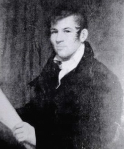
Portrait of John Randel Jr., the surveyor responsible for Manhattan’s street grid.
To this reader, however, the question of whether the grid was the result more of accident or of deliberation is far less important than the considerable light that Koeppel’s book sheds on the evolution of Manhattan’s topography and real estate. Koeppel does an excellent and thorough job explaining the prehistory of the grid and the survival of those earlier attempts at urban planning that are still evident in the lay of Manhattan as seen from the air or from Google Maps. For example, the southern tip of Manhattan, south of Wall Street, was of course the center of the original Dutch settlement, and is laid out according to the conventions of 17th-century Dutch urban planning. But between that southernmost point and the start of the Randel grid at 14th street are two other, earlier attempts at grids: the Bayard grid, which is roughly equivalent to modern Soho, and the Delancey grid, which accounts for much of the Lower East Side, both of which stand at oblique angles to Randel’s grid.
At the same time, and as important, the island of Manhattan once contained a number of other towns and villages that were, for centuries, entirely independent of New York City, although they were ultimately assimilated to the city’s relentless northward expansion. If Lower Manhattan still bears traces of the Dutch canals that originally informed it, and if the Bayard and Delancey grids still stand at oblique angles to Randel’s grid, the tangled streets of Greenwich Village attest to the English village that was once there.
Many New Yorkers may also not know that there was once a main road on the east side of the island — sometimes known as the Boston Post Road — that became unified with Broadway for about half a mile, starting at 14th Street, in what is still known accordingly as Union Square. This road was completely obliterated by the 1811 grid, except for a portion of the East Drive in Central Park — the only surviving trace of that once-great thoroughfare.
Koeppel also brings to life a number of the movers and shakers of Gotham real estate in earlier centuries. In addition to Randel, he introduces us to the surveyor Casimir Goerck, a Polish immigrant who married into the Roosevelt family. He was the one who, in the final years of the 18th century, conceived of a great north-south avenue — known now as “Fifth Avenue” — flanked by two others, each at a distance of 920 feet, Fourth and Sixth avenues.
Then there is Samuel Ruggles, the developer who created Gramercy Park and whom we have ultimately to thank for the fact that the distance between Fifth and Fourth avenues, as well as between Fourth and Third, was divided in half to create Madison and Lexington avenues. Finally, the extension of the grid above 155th Street, and the grid’s coexistence with such green interventions as Morningside Park, is largely thanks to Andrew Haswell Green, the man behind the integration of the five boroughs into Greater New York, in 1897.
Throughout, Koeppel exhibits a keen awareness of the evolution of real estate in Manhattan. “Mansions built on land that had once sheltered orphans,” he writes, “survive today as retail outlets for Cartier and Versace.” Moreover, the area stretching from about 23rd Street to about 95th Street transitioned “from the least to the most desirable Manhattan real estate…probably the greatest irony of the grid plan.”
City dwellers in general, but especially developers, are acutely interested in the future of their city. But they cannot rightly claim to be citizens of the first order until they have understood their city’s hidden past. Koeppel’s magisterial book should enable them to do both.
James Gardner is TRD’s architecture critic and the author of “Buenos Aires: The Biography of a City.”