
When millions of gallons of briny water gushed into the lower reaches of 80 Pine Street on October 29, 2012, concrete walls buckled, electrical systems shorted out and several maintenance workers briefly found themselves trapped.
That nightmarish scene in the Financial District was just one of many faced by building owners in the city in the wake of Superstorm Sandy. All told, their losses came to an estimated $8.6 billion. Given the scale of that hit, one would think that developers today would be wary of pouring cash into the city’s most vulnerable neighborhoods.
But surprisingly, for better and for worse, that has not been the case. Take Rudin Management [TRDataCustom], the private, family-run company that owns 80 Pine Street. Just three years after Sandy, the developer joined with Boston Properties to buy a 99-year ground lease on Dock 72 at the Brooklyn Navy Yard. There, they plan to put up a 556,000-square-foot office project on a dock surrounded by water on three sides. Not surprisingly, the site lies in in Flood Zone A, a designation reserved for areas at the highest risk.
“There are tradeoffs in life,” William Rudin, CEO of Rudin Management Company, told The Real Deal. “It’s beachfront property. There are risks and rewards. You do what you can to mitigate the risks.”
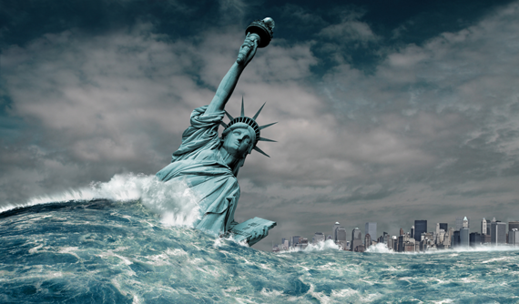
That, it turns out, is a tall order. Most climate-change scientists see Sandy as just a prelude. By the end of the century, sea levels could rise by at least six feet unless current trends in global warming can be modified. Last year, the New York City Panel on Climate Change predicted that by 2050, sea levels would rise by 30 inches. As a result, the city’s 100-year floodplain — areas that have a 1 percent chance of flooding in any given year — could grow to 72 square miles, up from 50 square miles today. Some of the city’s highest-profile projects fall within this projected floodplain. They include Hudson Yards, the Brooklyn Navy Yard and the World Trade Center, which were cited in an article in New York magazine last month about the gaping holes in the city’s preparedness for climate-change catastrophes.
 So what are the owners of New York City’s estimated $1 trillion-plus in real estate doing to fortify themselves against the rising tides?
Not nearly enough, according to many experts, including sustainable developers, architects and engineers, who spoke to TRD.
“I don’t think we have really begun to address the issues,” said Jonathan Rose, a developer who specializes in sustainable housing and was part of a Metropolitan Transportation Authority panel that recommended a series of flood-protection measures five years before Sandy struck. “I think we need a more proactive long-range plan and that every real estate owner should understand what their potential risks are, and what their options are.”
For a typically risk-averse industry, the response to the dangers of rising sea levels, overall, has been surprisingly muted. While most developers will address flood risk on an individual-property, short-term basis, few have shied away from investing in the city’s most flood-prone areas. There, some landlords seem willing to put their faith in a number of large-scale publicly funded projects designed to protect low-lying areas. Many of those projects, however, have yet be fully designed, much less funded. And while both the government and private landlords are working to keep raging storm waters at bay, those efforts have yet to begin to address the longer-term threats of large swaths of the city being submerged.
Richard Roark, a partner at the landscape-architecture firm OLIN who was part of the team selected by the city for the redevelopment of Hunts Point, said that while there’s a good deal of focus on making waterfront areas like Hunts Point resilient, it is at risk of fading along with now four-year-old memories of Sandy. The city, he said, has a long way to go when it comes to private and public development “comfortably tackling climate change together,” especially when it comes to the city’s aging infrastructure.
“We sort of have this nonplanning mentality right now that is doing us harm as a country as a whole,” Roark argued. “We can’t move everybody out of the way, and we need our cities to have a relationship to the coast, but we can’t pretend those risks aren’t there.”
Similarly, Chris Ward, chief executive of the Metro New York unit of engineering firm AECOM, said that when it comes to climate change and rising sea levels, there is “a fair degree of complacency.”
In the end, climate change demands that the real estate sector confront a fundamental but uncomfortable existential question about the city as a whole. As Ward put it, “What is an archipelago city like New York to become?”
A horizon problem
Lisa Dickson, associate principal of the climate risk and resiliency department at Arup, said her engineering firm’s clients typically only think in terms of how their properties will be impacted in the next 30 to 50 years — the life cycle of a mortgage, or until the holding will be sold off. “I think people are overwhelmed,” she said. “It becomes such a daunting issue that no matter what happens, nothing can be done.”
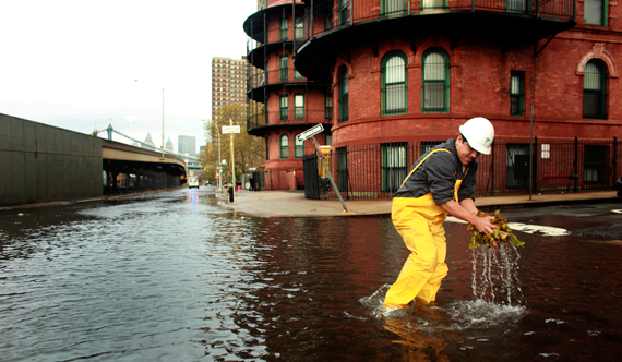
A scene from Lower Manhattan the day after Hurricane Sandy
In what frequently becomes a balancing act between the risk and the payoff of a location that comes with sweeping waterfront views, the vistas tend to win out. That leaves it up to the developers to build resiliency into their projects, as Rudin aims to do at Dock 72 in the Navy Yard. He calls the $380 million project a poster child for how to embark on a new project post-Sandy. Case in point, the building’s second floor is elevated more than 40 feet over ground level, well above the federally designated floodplain. He also expressed confidence that the building can “withstand quite a pounding.” Even when it comes to the longer-horizon question of where Dock 72 will stand vis-a-vis sea levels 100 years from now, Rudin’s partners show little worry.
“It’s calculated. Do we know where all of this is going to go? No. Do we think this building will be here in 100 years? Yes,” said Robert Schubert, senior vice president of construction at Boston Properties. “Are we going out for 500 years? No, but I don’t think anyone’s expecting that.”
To find further proof that developers and the city are undeterred by the prospect of climate change, look no further than Pier 55, the proposed 2.4-acre city-owned park development off Manhattan’s West Side that business magnate Barry Diller is financing. The park will literally sit in the Hudson River, atop a platform ranging from 15 feet to 70 feet above the water — the former being the minimum recommended by Federal Emergency Management Agency (FEMA) flood maps.
But even while the city and developers like Rudin and Boston Properties assert they are doing everything they can do protect their properties, the lingering issue is that even if an individual property has been made resilient, what about those around it and the neighborhood in general?
At Hudson Yards, for example, the 26-acre multitower project now rising west of Penn Station, flood resiliency is touted as being built into the design, with most of the project sitting on a platform that rises 40 feet above sea level. Jessica Scaperotti, a spokesperson for the developer Related Companies, also pointed out that the development will have its own microgrid and two cogeneration plants.
“Whatever the disruption — superstorm, brownout — we will have the on-site power-generation capacity to keep basic building services, residences and restaurant refrigerators running,” she said.
Still, it’s important to note that 10 Hudson Yards, the office tower at 30th Street and 10th Avenue, is not on the platform. Moreover, the entire project’s vitality hinges on two transit lifelines — the No. 7 train and Penn Station.
Jim Crispino, president and design principal of architecture firm Francis Cauffman, said planning for the long term can be difficult when it’s not clear if the rest of the city will be fortified against floodwaters.
“You can design your apartment building for a 500-year storm,” he said, “but if that storm basically wipes out the city, and the power grid, the telephone grid and everything else, what’s the point?”
The problem is even more difficult for owners of existing commercial and residential properties. Following Sandy, Brookfield Properties, one of the biggest landlords in Lower Manhattan, rebuilt its destroyed below-grade shopping mall at One New York Plaza. Sandy had swamped the 31,000-square-foot retail concourse with an estimated 23 million gallons of water.
Daniel Kindbergh, Brookfield Properties’ executive vice president of U.S. operations, said doing away with the low-lying retail was never a serious option.
“We talked about it briefly, but it’s a valuable area,” he said. “This was a once-in-an-88-year storm, and we felt that we could come up with mitigation measures that will protect the property should that happen again.”
Over the next eight months, Kindbergh said, Brookfield will add floodgates to the property. Many developers in the city’s most vulnerable areas have gone down that road, while many others have shifted their buildings’ electrical equipment to higher floors. Those measures can prove pricey, not just because of the cost of the move but because the equipment will take up space that formerly generated solid revenues. Building experts estimate such flood-remediation measures can add 5 percent to 10 percent to a project’s overall cost. It’s also cheaper and easier to design a new building to cope with flooding than to adapt an older one. In extant buildings, electrical equipment ranging from elevator motors to communications switches is generally housed in the bowels of the property, creating a vulnerability made painfully apparent when Sandy hit four years ago.
City initiatives
Over the next century, Sandy-caliber storms could hit the city every 20 years, according to a new study published in the Proceedings of the National Academy of Sciences, the group’s official journal. Meanwhile, FEMA’s flood maps for New York City haven’t been updated since 1983. In recent years, the city has pushed FEMA to be more cautious in determining which areas face risks of flooding so that more homeowners aren’t on the hook for costly flood insurance. Just last month, Mayor Bill de Blasio announced that the city and FEMA had cut a deal to redraw the flood maps to better depict both the current and future risks of flooding in the city.
Establishing those two benchmarks is key, since the city has campaigned in recent years to separate the future risk of rising sea levels from how flood insurance is calculated today. In other words, the city doesn’t want property owners to pay for flood risk based on the forecast future conditions, due to the cost burden. At the same time, the city has recognized the importance of realistically portraying what lies ahead, beyond just the year-to-year risk.
In 2015, FEMA had proposed changes to its maps that would have added over 35,000 homes and commercial buildings to the floodplain, a move that could have increased flood-insurance premiums for homeowners in high-risk areas to $14,500 annually by 2030, up from $1,000. In the future, flood-insurance costs will be based on current flood risk. A second map detailing flood risks further out in time will be used to guide building and zoning codes to adequately prepare buildings for what’s to come, said Daniel Zarrilli, who heads the city’s Climate Policy and Program. He noted that the city has passed 16 local laws to upgrade building codes to post-Sandy standards. He termed the moves important for the private and public sectors.
“I give the private real estate industry a lot of credit for measures they’ve taken across the city, particularly in areas like Lower Manhattan,” Zarrilli said. “But it’s important to take a step back and realize that individual buildings can be protected, and that is an effective tool, but it’s even more effective when the neighborhood-level protections that we’re advancing are in place.”
Much of the groundwork for those efforts was laid by Mayor Michael Bloomberg. Shortly before leaving office, he released a 430-page report outlining $20 billion worth of recommendations to protect neighborhoods from climate risks. In March 2014, the de Blasio administration formed the city’s Office of Recovery and Resiliency to start implementing those recommendations. The mayor also committed to reducing New York’s greenhouse-gas emissions by 80 percent by 2050, upgrading Bloomberg’s goal of cutting citywide emissions by 30 percent by 2030. While such cuts are critical to curbing global warming, the outlook for doing so in a meaningful way remains pretty bleak. This year, 195 nations agreed to help limit temperature increases to 1.5 degrees Celsius through the Paris Agreement, a measure lauded as a landmark climate accord. Nonetheless, scientists have warned that the globe already stands close to passing this threshold.
In the meantime, construction continues in some of the city’s most vulnerable neighborhoods. In June, the City Council approved a rezoning in the Financial District that would encourage property owners to fill in unused arcade space along Water Street with some 110,000 square feet of retail. It’s unclear if landlords will be required to install expensive “aquarium glass” in these new spaces or the detachable metal shields that the city’s Planning Department initially recommended, according to Crain’s New York Business. One way or the other, the new ground-level retail must be able to handle floodwaters as high as 12 feet.
To guard against such inundations, the city has various resiliency projects in the planning stages. Among them is the Lower Manhattan Coastal Resiliency Project, part of a $3.7 billion coastal defense initiative that also ropes in projects in Red Hook in Brooklyn and Hunts Point in the Bronx. This year, the city tapped AECOM and engineering firm Dewberry to design a 3.5-mile section of the “Big U,” a waterfront park wrapping around Lower Manhattan that will serve as a barrier against floodwaters. Danish architect Bjarke Ingels was part of the team selected to design another section of the U, dubbed the “Dryline,” as part of the federal “Rebuild by Design” competition.
Yet critics have said that the project is not designed to deal with climate-change events beyond the end of the century.
“It’s not a one-fix cure-all,” Ward conceded. “The solution needs to be a long-term major reimagining of the edge. But I think the Lower Manhattan plan is definitely the start. Funding remains an enormous question.”